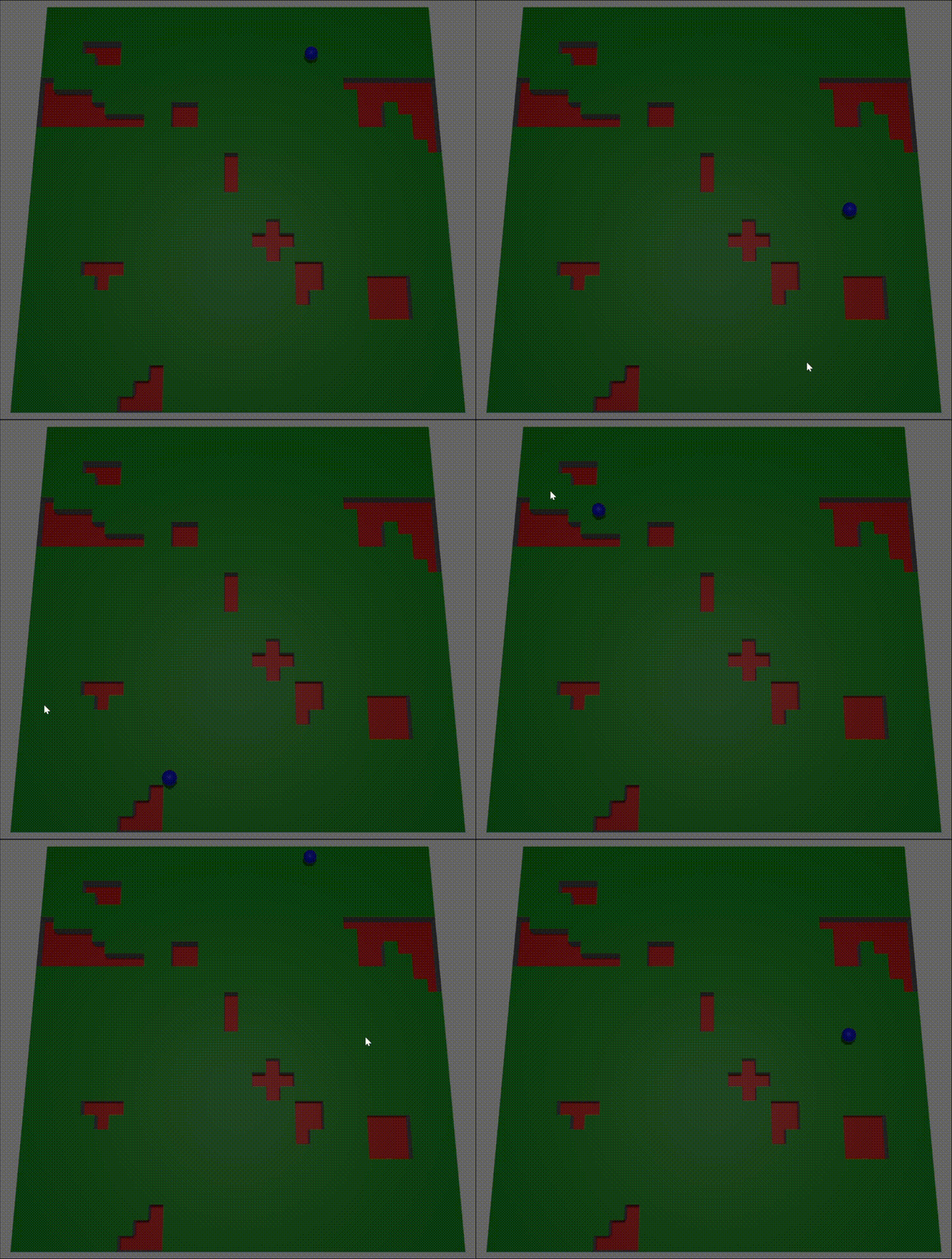
Inspired by the work of Elijah Emerson and with inspiration from leifnode and jdxdev this is an attempt to implement the data structures and logic required to generate a Flowfield representation of a world which can be used to pathfind movable actors.
| bevy | bevy_flowfield_tiles_plugin |
|---|---|
| 0.14 | 0.10 - 0.11 |
| 0.13 | 0.7 - 0.9 |
| 0.12 | 0.5 - 0.6 |
| 0.11 | 0.1 - 0.4 |
Pathfinding in games can take different forms and those forms have certain benefits aligned with the type of game they are being applied to. Generally people run across:
- Way-point Graph - points in space linked together, very strict structure, an actor will move from one way-point to another. Great for games played on a small grid where movement needs to be restricted to precise lines, will be cumbersome when multiple actors are sharing a path - particularly when actors have some kind of collision system in place
- NavMesh - a walkable surface generated from the topology of meshes in a game world defining a valid area of movement. It allows for a range of dynamic movement within the confines of the mesh and is a natural evolution of the Way-point Graph
- FlowField Tiles - a means of handling crowd and flocking behaviour by generating a flow field (vector field) describing how an actor flows across a world. A large number of actors can flow in unison to an endpoint while sharing the same pathing data structure - saving compute resources and time
For larger and larger environemnts with an increasing number of pathing actors it may be beneficial to adopt a FlowField based approach due to the data sharing and formation/group like movement it promotes. FlowField Tiles are complex, it's effectively akin to fluid mechanics, so this is an attempt to bring an agnostic implementation to the Bevy game engine. My motivation for this is that I recently implemented a Way-point Graph for a prototype. In order to provide 'ok' actor movement it had to be made from 16 million data points. To prevent an actor from occasionally zig-zagging across the game world the granularity had to be boosted to 80 million data points to create a 'lifelike' impression of movement. That was just silly so I began looking into the history of pathfinding whereupon I stumbled across FlowField Tiles and decided to try and implement it with my favourite langauge and engine.
- Sector - a slice of a game world composed of three 2D arrays called fields (
CostField,IntegrationFieldandFlowField). A game world is effectively represented by a number of Sectors - CostField - a 2D array describing how difficult it is to path through each cell of the array. It is always present in system memory
- Cost - how difficult/expensive it is to path somewhere, you could also call it weight, each cell of
CostFieldhas one of these - Portal - a navigatable point which links one Sector to another to enable movement from one side of the world to another
- IntegrationField - a 2D array which uses the CostField to determine a cumulative cost of reaching the goal/endpoint (where you want to path to). This is an ephemeral field - it exists when required to calculate a
FlowField - FlowField - a 2D array built from the
IntegrationFieldwhich decribes how an actor should move (flow) across the world - FlowField Cache - a means of storing
FlowFieldsallowing multiple actors to use and reuse them - Ordinal - a direction based on traditional compass ordinals: N, NE, E, SE, S, SW, W, NW. Used for discovery of Sectors/field cells at various points within the algorithm
- Field cell - an element of a 2D array
- Goal - the target field cell an actor needs to path to
- Portal goal - a target point within a sector that allows an actor to transition to another sector, thus bringing it closer towards/to the goal
To generate a set of navigation FlowFields the game world is divided into Sectors indexed by (column, row) and each Sector has 3 layers of data: [CostField, IntegrationField, Flowfield]. Each layer aids the next in building out a path. A concept of Portals is used to connect Sectors together.
Click to expand!
For a 3-dimensional world the x-z (x-y in 2d) plane defines the number of Sectors used to represent it with a scale factor called sector_resolution. This means that a for a (30, 30) world with a resolution of 10 there would be 3x3 Sectors representing it - this implies that a single sector has relative dimensions of (10, 10) and a single field cell within a sector represents a 1x1 unit area. Each Sector has an associated unqiue ID taken as its position: (column, row).
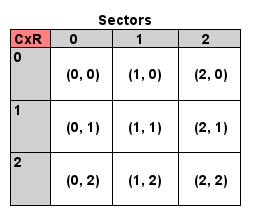
Likewise for a (300, 550) resolution 10 world you'll be looking at 30 columns and 55 rows. The advantage of dividing a world into Sectors (as opposed to treating the whole world as a giant Flowfield) is that the work in generating a path can be split into multiple operations and only touch certain sectors. Say for the (300, 550) world you do treat it as a single set of fields - when calculating a path you could potentially have to calculate the Flowfield values for 165,000 field cells. Splitting it into sectors may mean that your path only takes you through 20 sectors, thereby only requiring 2,000 Flowfield field cells to be calculated.
Click to expand!
A CostField is an MxN 2D array of 8-bit values, by default this is always a 10x10 array. The values indicate the cost of navigating through that cell of the field. A value of 1 is the default and indicates the easiest cost, and a value of 255 is a special value used to indicate that the field cell is impassable - this could be used to indicate a wall or obstacle. All other values from 2-254 represent increasing cost, for instance a slope or difficult terrain such as a marsh. The idea is that the pathfinding calculations will favour cells with a smaller value before any others.
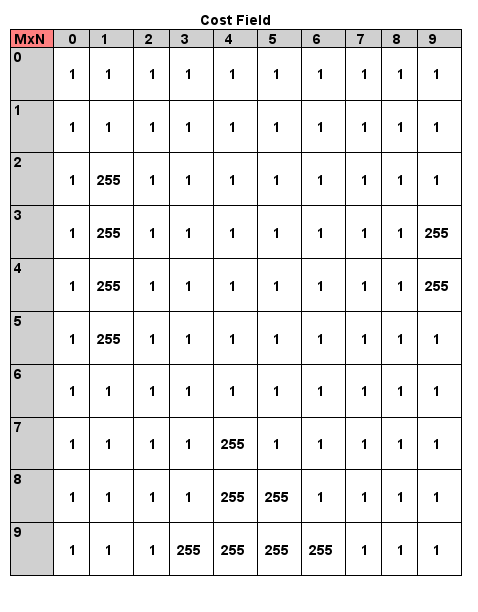
At runtime the CostField is generated for each Sector with the default value - although with the feature ron it is possible to load the fields from disk, or with the feature heightmap a greyscale png/jpeg can be used to seed the fields. See the Usage section below for details on updating the CostFields during an inital pass (i.e when loading a level) and tweaking it during gameplay for a world which dynamically evolves with obstacles (flipping a cell to to a higher cost or an impassable 255 when something like a wall is placed or the ground splits into a fissure).
This array is used to generate the IntegrationField when requesting a navigatable path.
Click to expand!
Each Sector has up to 4 boundaries with neighbouring Sectors (fewer when the sector is in a corner or along the edge of the game world). Each boundary can contain Portals which indicate a navigatable point from the current Sector to a neighbour. Portals serve a dual purpose, one of which is to provide responsiveness - FlowFields may take time to generate so when an actor needs to move a quick A* pathing query can produce an inital path route based on moving from one Portal to another and they can start moving in the general direction to the goal/target/endpoint. Once the FlowFields have been built the actor can switch to using them for granular navigation instead.
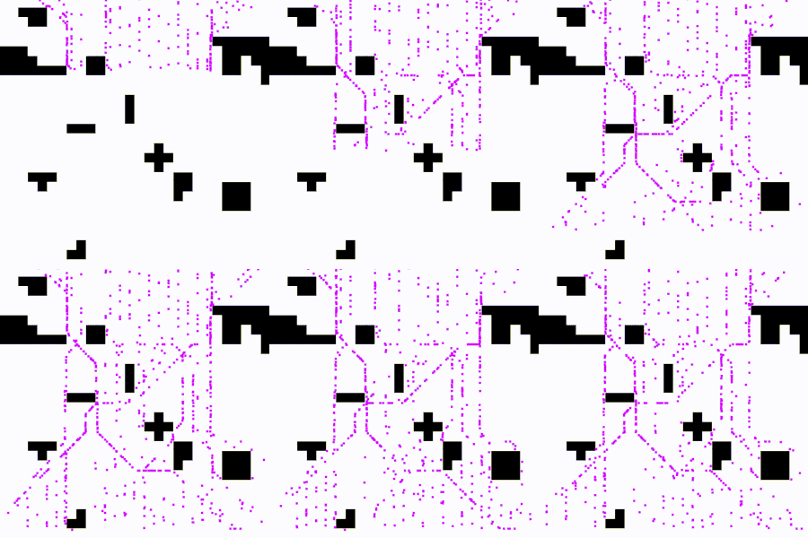
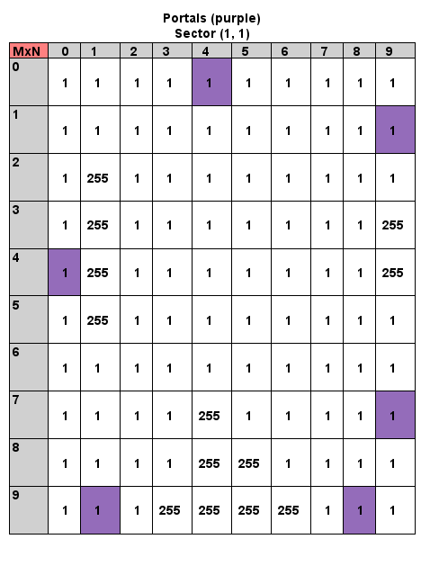
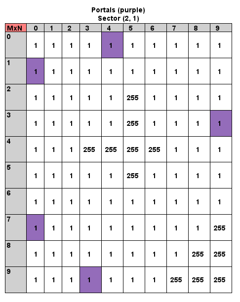
The following sectors are located away from any edges of the world which means each boundary can have Portals (the purple cells):
A Portal is generated at the midpoint of a boundary - in situations where the CostField contains 255 costs along the edge then multiple Portals may be generated at the midpoint of each valid pathable segment along the boundary and this is propagated to neighbouring Sectors so that every Portal has a neighbour buddy (as evident in the right hand Sector above, S(1, 1) portal (9, 1) allows movement into S(2, 1) portal (0, 1), even though S(2, 1) has a whole boundary that appears completely pathable).
On a larger scale (but still small) and for the simplist CostField available, a 2x2 Sector grid produces predictable boundary Portals.
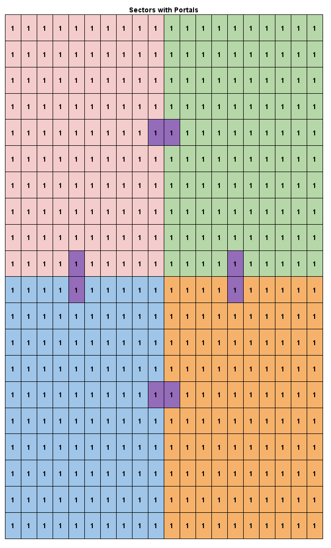
For finding a path from one Sector to another at a Portal level all Sector Portals are recorded within a data strucutre known as PortalGraph. The Portals are stored as Nodes and Edges are created between them to represent traversable paths, it gets built in three stages:
- For all Portals add a graph
node - For each sector create
edges(pathable routes) to and from each Portalnode- effectively create internal walkable routes of each sector - Create
edgesacross the Portalnodeon all sector boundaries (walkable route from one sector to another)
This allows the graph to be queried with a source sector and a target sector and a list of Portals are returned which can be pathed. When a CostField is changed this triggers the regeneration of the sector Portals for the region that CostField resides in (and its neighbours to ensure homogenous boundaries) and the graph is updated with any new Portals nodes and the old ones are removed.
Click to expand!
An IntegrationField is an MxN 2D array of 32-bit values. It uses the CostField to produce a cumulative cost to reach the end goal/target. It's an ephemeral field, as in it gets built for a required sector and then consumed by the FlowField calculation. The first 16-bits of each field cell value are used for a cost measurement while the second 16-bits are used as flags to indicate certain properties of a cell. The flags are classified as:
- INT_BITS_LOS - indicates Line Of Sight from the cell to the goal cell
- INT_BITS_GOAL - indicates the cell is the goal
- INT_BITS_CORNER - indicates a point where Line Of Sight may be broken and is used to discover which cells should be marked as
INT_BITS_WAVE_BLOCKED - INT_BITS_WAVE_BLOCKED - marks cells to prevent Line Of Sight from being propagated around corners
- INT_BITS_PORTAL - marks cells that are portals between sectors
- INT_BITS_IMPASSABLE - marks a cell that cannot be pathed through
When a new route needs to be processed the first 16-bits of the field values are set to u16::MAX and the field cell containing the goal is set to 0. Any cells which are impassable in the CostField are marked in the IntegrationField with their second 16-bits as INT_BITS_IMPASSABLE.
The IntegrationField is built from a number of passes:
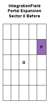
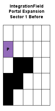
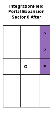
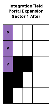
A Portal represents the midpoint of a traversable sector boundary, when generating the field we expand the portals to cover their entire segment - this increases efficiency so that an actor can more directly approach its goal rather than zig-zagging to portal boundary points.
Note that portals are only expanded to field cells if they are pathable from both neighbouring sectors, a neighbour that has impassable cells will shorten the pathable segemnt.
In order to reduce needless pathfinding near the goal a Line Of Sight (LOS) pass is performed from the goal Sector. The idea being that if an actor moves into a field cell that has LOS then it no longer needs to follow the FlowFields and can instead directly path to the goal.
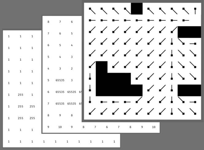
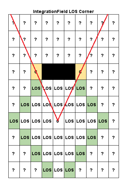
The LOS phase begins as a wavefront from the goal that interrogates the adjacent neighbouring field cells. If an adjacent cell is not marked as impasssable then it must have LOS to the goal and the value of the cell receives a wavefront cost plus the LOS bit flag. The wavefront then expands (whereby the wavefront cost increments by 1) to interrogate the adjacent cells of the neighbours and repeats until the wavefront cannot propagate any further.

As the wavefront expands it may encounter an impassable field cell (a block box in the diagrams). This causes two things to happen:
First, wavefront expansion cannot continue in the direction of the impassable field cell so it is removed from being a candidate in the next round of wavefront propagation.
Second, if there is a vacant field cell next to the impassable field cell then this indicates a Corner. A Corner means that LOS will be blocked in a given direction and the Corner is recorded for stage 3, the integrated cost calculation.
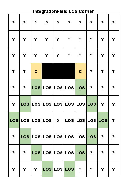
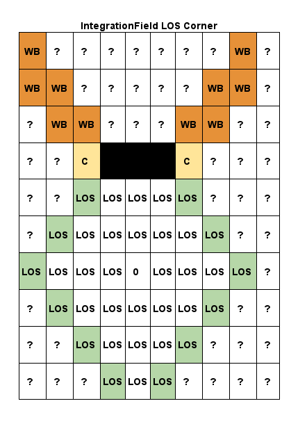
By taking a vector from the starting goal to the corner we can then extend this vector to calculate what field cells lie along a line. The field cells on this line are stored as corners and are updated with the flag for WavefrontBlocked. Meaning that as LOS expands and propagates if a WavefrontBlocked cell is encountered then the cell is removed as a candidate in further LOS porpagation. This ensures that LOS cannot flow around impassable areas.
Any available LOS propagation continues until all possible cells are exhausted:
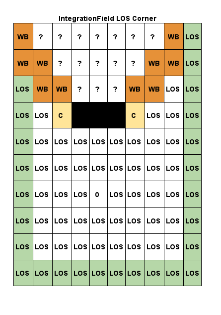
Once the wavefront has exhausted expansion from either hitting the sector boundaries or from impassable cells/corners we can then calculate the actual integrated cost of the field.
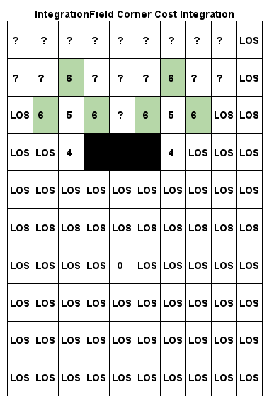
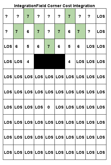
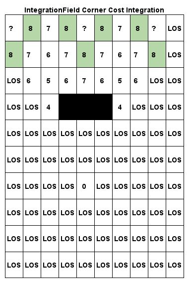
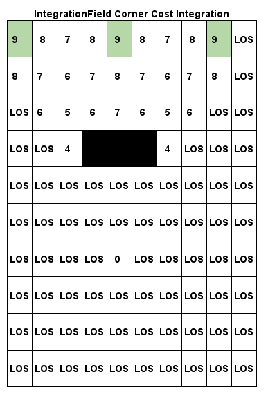
From the Corners of an IntegrationField recorded previously we start a new series of wavefronts that radiate from the corners considering any adjacent field cells that have not been marked as LOS or impassable.
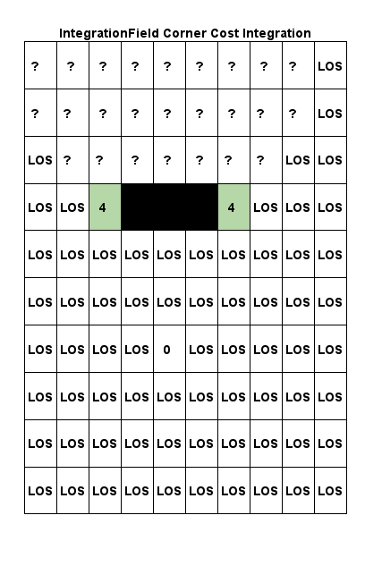
To calculate the cost of the cells in the field:
- The valid ordinal neighbours of the corners are determined (one, none or many of North, East, South, West)
- For each ordinal field cell lookup their
CostFieldvalue - Add the
CostFieldcost to theIntegrationFieldscost of the current cell (at the corner the wavefront cost assigned was 4, assuming theCostFieldvalue of the adjacent cell is1then the integrated cost becomes5)
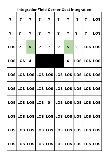
- Wavefront propagates to the next neighbours, find their ordinals and repeat adding their cost value to to the current cells integration cost to produce their cumulative integration cost, and repeat until the entire field is done
The end result effectively produces a gradient of high numbers to low numbers, a flow of sorts.
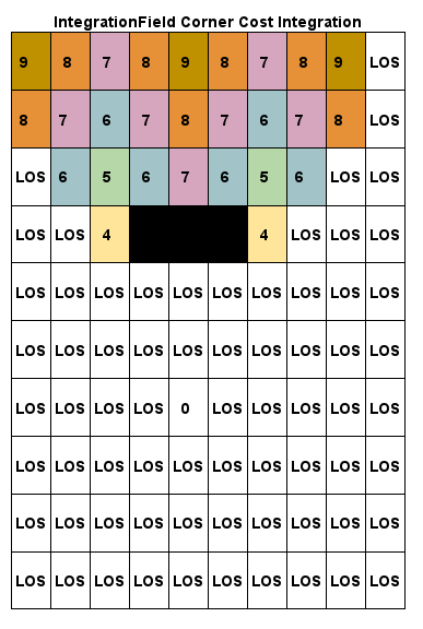
For Sectors other than the goal the process is effectively the same where boundary portals are treated as corners and wave propagation exapaned.
NB: the following diagrams use smaller sector sizes and exclude LOS but demonstrate how integrated cost is accumulated and creates a gradient from portal to portal
From the PortalGraph we can get a path of Portals to guide the actor over several sectors to the desired sector, the IntegrationField of the goal sector has been calculated so next we "hop" through the boundary Portals working backwards from the goal sector to the actor sector (Portals are denoted as a purple shade) to produce a series of IntegrationFields for the chaining Sectors describing the flow movement.
In terms of pathfinding the actor will favour flowing "downhill". From the position of the actor and looking at its field cell neighbours a smalller value in that sectors IntegrationField means a more favourable point for reaching the end goal, going from smaller to smaller values, basically a gradient flowing downhill to the destination.
This informs the basis of a FlowField.
As an example for a 30x30 world (manually calculated), goal at 0 with an actor at A, an IntegrationField set interrogating all sector Portals may produce a set of fields looking similar to:
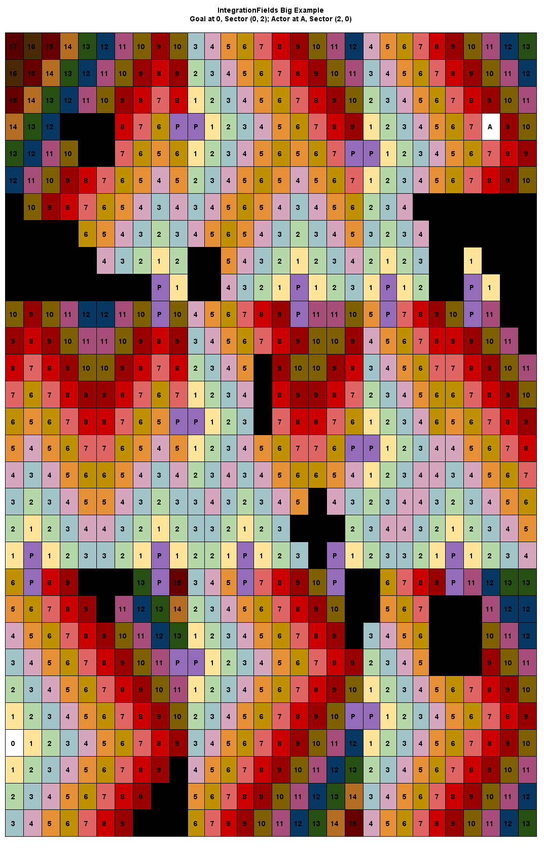
Notice the cool waves that propagate out from the goal!
Generating the fields for this path programmatically leads to:
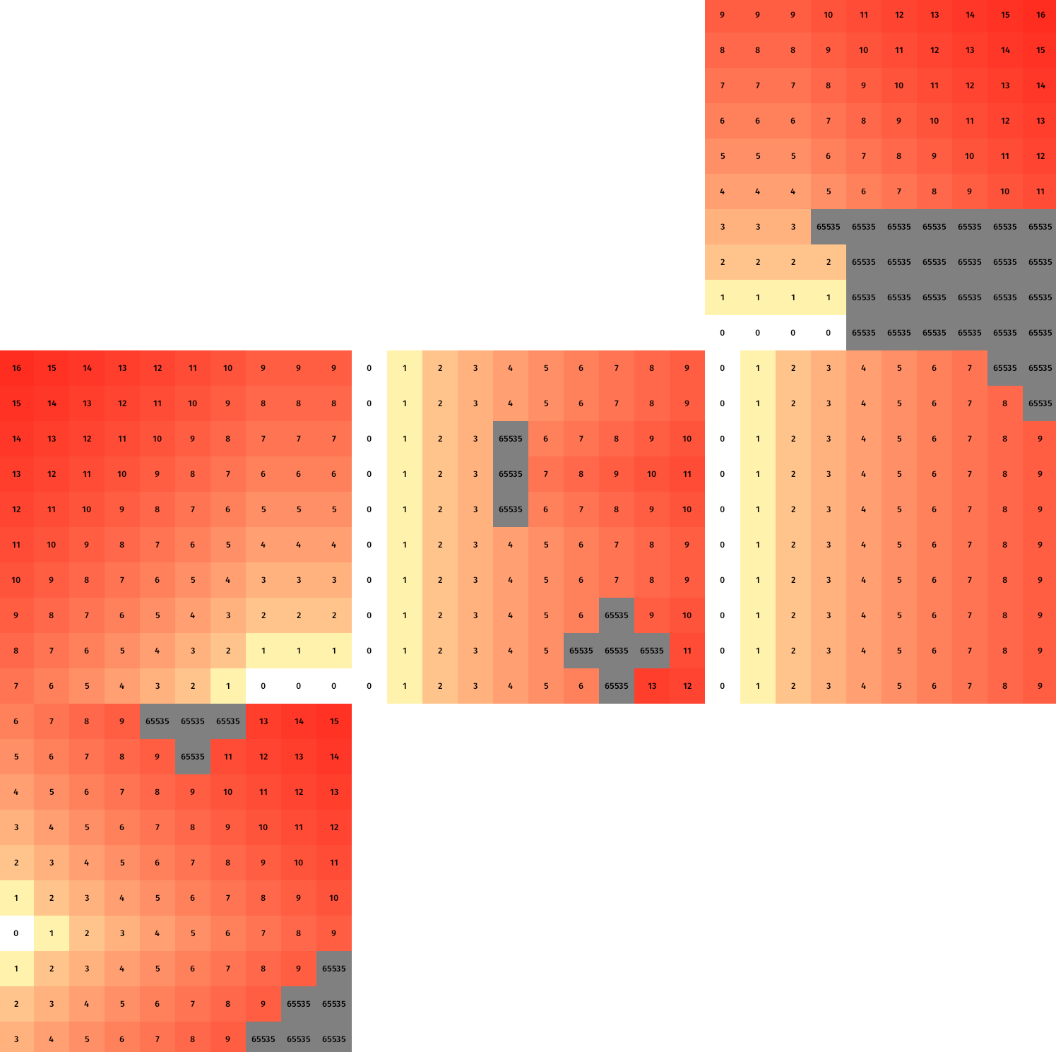
From the IntegrationFields we can now build the final set of fields - FlowFields
Click to expand!
A FlowField is an MxN 2D array of 8-bit values built from a Sectors IntegrationField. The first 4 bits of the value correspond to one of eight ordinal movement directions an actor can take (plus a zero vector when impassable) and the second 4 bits correspond to flags which should be used by a character controller/steering pipeline to follow a path.
The directional bits are defined as:
0b0000_0001- North0b0000_0010- East0b0000_0100- South0b0000_1000- West0b0000_0011- North-East0b0000_0110- South-East0b0000_1100- South-West0b0000_1001- North-West0b0000_0000- zero vector, represents impassable cells0b0000_1111- default onFlowFieldinitialisation, is always replaced by other values
The assistant flags are defined as:
0b0001_0000- pathable0b0010_0000- has line-of-sight to goal, an actor no longer needs to follow the field, it can move in a straight line to the goal. This avoids calculating field values that aren't actually needed and once an actor enters a cell with this flag then they no longer need to spend time looking up a `FlowField``0b0100_0000- indicates the goal0b1000_0000- indicates a portal goal leading to the next sector
So a field cell in the FlowField with a value of 0b0001_0110 means the actor should flow in the South-East direction. In terms of use don't worry about understanding these bit values too much, the Usage section shows the helpers for interpreting the values of the FlowField to steer an actor.
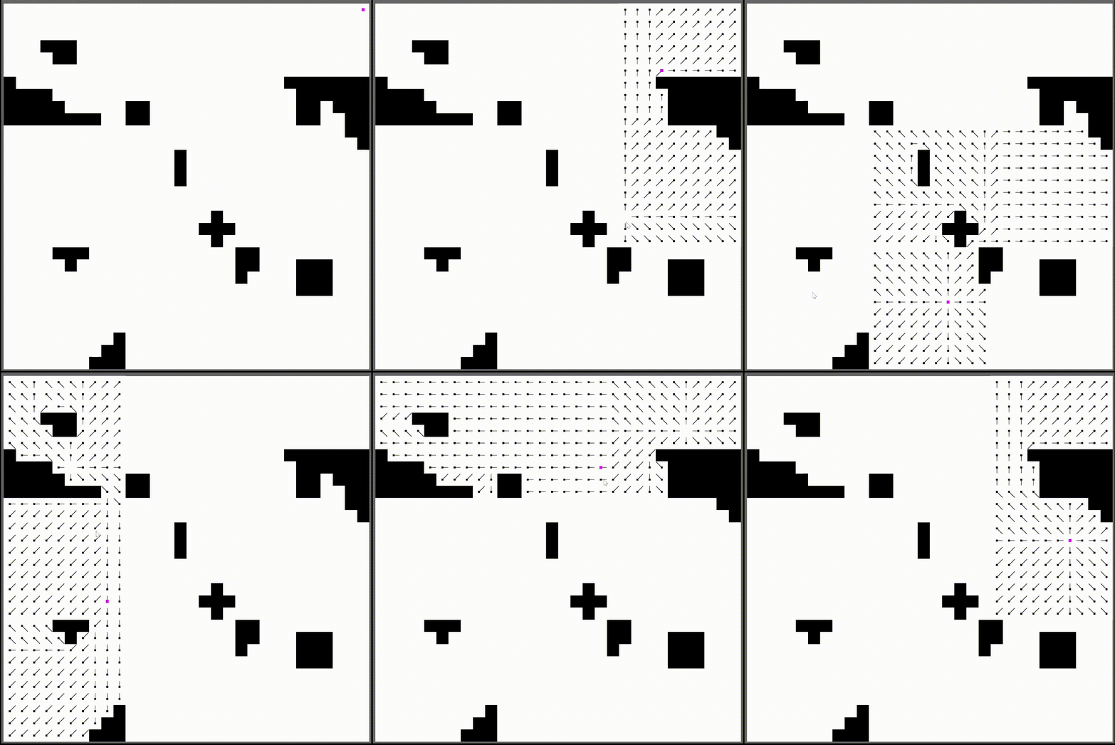
Using the IntegrationFields generated before, with an actor in the top right trying to reach the bottom left, we now generate the FlowFields:
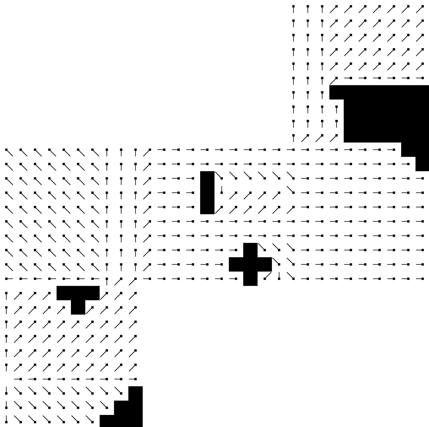
The thinner porition of each cell icon indicates the flow direction. The actor runs along the flow lines leading to the goal. This means for a group of actors they will flow towards the goal with a formation-like behaviour along the flow lines.
Click to expand!
To enable actors to reuse FlowFields (thus avoiding repeated calculations) a pair of caches are used to store pathing data:
-
Route Cache - when an actor requests to go somewhere a high-level route is generated from describing the overall series of sector-portals to traverse (
PortalGraphA*). If aFlowFieldhasn't yet been calculated then an actor can use theroute_cacheas a fallback to gain a generalist direction they should start moving in. Once theFlowFieldshave been built they can swap over to using those more granular paths. TODO:Additionally changes toCostFieldscan change portal positions and the real best path, soFlowFieldsare regenerated for the relevant sectors thatCostFieldshave modified and during the regeneration steps an actor can once again use the high-level route as the fallback -
Field Cache - for every sector-to-portal part of a route a
FlowFieldis built and stored in the cache. Actors can poll this cache to get the true flow direction to their goal. A Character Controller/Steering Pipeline is responsible for interpreting the values of theFlowFieldto produce movement - while this plugin includes a Steering Pipeline the reality is that every game has it's own quirks and desires for movement so you will most likely want to build your own Pipeline. The real point of this plugin is to encapulsate the data structures and logic to make aFlowFieldwhich an Actor can then read through it's own implementation.
Note that the data stored in the caches is timestamped - if a record lives longer than 15 minutes then it is purged to reduce size and improve lookup efficiency. When implemnting a steering pipeline/character controller to interpret the FlowFields you may need to account for these old routes/paths expiring.
Click to expand!
In a simulation you may have actors of different sizes and a gap between impassable walls, consider these purple actors:

The smaller actor on the left can evidently pass through the gap between the impassable terrain. On the right however the actor is much larger and as such when processing a PathRequest only routes with suitable clearance should be considered (otherwise with a collision system in place it'd just bump into the walls to the side and never make it through).
To handle this the overall MapDimenions component which defines the sizing of the various fields contains an actor_scale parameter. This scaling is determined by the actor size and unit-size of a cell within a field. For instance a Sector with pixel dimensions of 640x640 means that each cell in the (m, n) -> (10, 10) fields represents a pixel area of 64x64, if an actor is larger than 64 pixels in width then a ratio between actor size and cell size is applied to 'grow' impassable cells to close off gaps that would be too small for the actor to path through.
In terms of what an actor 'sees' after requesting a route, the smaller actor on the left can path through the gap whereas the larger actor on the right would search for an alternate route:

In a game with actors of multiple sizes you will want to create distinct entities from FlowFieldTilesBundle where each is configured to handle a certain size of actor.
#[derive(Component)]
struct ActorSmall
#[derive(Component)]
struct ActorLarge

fn setup () {
    let map_length = 1920;
    let map_depth = 1920;
    let sector_resolution = 640;

    let actor_size_small = 16.0;
    cmds.spawn(FlowFieldTilesBundle::new(
        map_length,
        map_depth,
        sector_resolution,
        actor_size_small
    )).insert(ActorSmall);

    let actor_size_large = 78.0;
    cmds.spawn(FlowFieldTilesBundle::new(
        map_length,
        map_depth,
        sector_resolution,
        actor_size_large
    )).insert(ActorLarge);
}

fn system_navigation_small_actors(
    actor_q: Query<&Actor, With<ActorSmall>>,
    field_q: Query<&FlowCache, With<ActorSmall>>
) {/* handling movement etc */}

fn system_navigation_large_actors(
    actor_q: Query<&Actor, With<ActorLarge>>,
    field_q: Query<&FlowCache, With<ActorLarge>>
) {/* handling movement etc */}Update your Cargo.toml and add any features you require, to actually interface with calculated fields you should enable either 2d or 3d depending on the coordinate system of your world:
[dependencies]
bevy_flowfield_tiles_plugin = { version = "0.x", features = ["3d"] }Add the plugin to your app:
use bevy_flowfield_tiles_plugin::prelude::*;

fn main() {
    App::new()
        // ... snip
        .add_plugins(FlowFieldTilesPlugin)
        // ... snip
}In your own simulation you may well be using custom schedules or stages to control logic execution, the plugin as is sets all the logic to run as part of the PreUpdate phase of the main Bevy schedule. To implement the logic into your own scheduling disect the contents of plugin/mod.rs - note that certain systems have been chained together and they must remain chained for accurate paths to be computed.
Next it's time to spawn the bundle entity configured to your world size (looking through the examples will give some pointers on this too).
The size and resolution of the world need to be known at initialisation and three values are required:
map_length- in 2d this refers to the pixelxsize of the world. In 3d this is simply thexsizemap_depth- in 2d this refers to the pixelysize of the world. In 3d this is thezsizesector_resolution- determines the numder of sectors by taking each size and dividing them by this value. In 2d this is basically the pixel length of each sector side and likewise for 3d it's the length of each sector side using whatever unit of measurement you've defined (for ease of use I go with a unit ofxis 1 meter and a unit ofzis one meter)- 2d: a world of pixel size
(1920, 1080)with a resolution of40will produce 48x27 sectors. Another way of looking at this could be based on the idea of having a world made of sprites where each sprite corresponds to where aFieldCellwould be. If these regular sized sprites have a pixel length and height of64and your world is made from a20x20grid of these sprites then you can calcualte what the size is.map_lengthwould be your sprite length multiplied by the number sprites along thexaxis of the world, i.e64 * 20 = 1280.map_depthfollows a likewise calculation64 * 20 = 1280. As for resolution it will depend on how granular you want, in this example case a10x10CostFieldis supposed to overlay an exact number of sprites so we use the sprite size to find the resolution64 * 10 = 640. - 3d: a world of size
(780x440)with resolution10produces78x44sectors. Given that fields are10x10arrays this translates to a singleFieldCellrepresenting a1x1unit area
- 2d: a world of pixel size
Within a system somewhere you can spawn the Bundle:
fn my_system(mut cmds: Commands) {
    let map_length = 1920;
    let map_depth = 1920;
    let sector_resolution = 640;
    let actor_size = 16.0;
    cmds.spawn(FlowFieldTilesBundle::new(map_length, map_depth, sector_resolution, actor_size));
}
Note that this will initialise all the CostFields representing the world with cell values of 1. Meaning everywhere is pathable, in all likihood you'll then need to seed the fields with true values.
In 3d you could consider making a raycast to the centre of where each FieldCell would be and use something like the y position of the ray hit to determine if something is passable or not and then flip the value of that particular FieldCell (EventUpdateCostfieldsCell can be used to queue a cost change).
Most likely for 2d or more complex 3d scenarios you'll probably want to enable either the ron, csv or heightmap feature which allows for creating a FlowFieldTilesBundle with inital CostFields from a .ron file, a collection of .csv or a greyscale png/jpeg where pixel colour channels are translated into costs, the examples showcase this in more detail.
When it comes to interacting with the algorithm this is based on an event to be emitted when a movable actor needs a path:
struct EventPathRequest {
    /// The starting sector of the request
    source_sector: SectorID,
    /// The starting field cell of the starting sector
    source_field_cell: FieldCell,
    /// The sector to try and find a path to
    target_sector: SectorID,
    /// The field cell in the target sector to find a path to
    target_goal: FieldCell,
}
Each parameter can be determined by querying the MapDimension component of the Bundle with the starting and end Transform::translation of actor position and target position.
Using some example components to track and label an Actor:
/// Enables easy querying of Actor entities
#[derive(Component)]
struct Actor;
/// Consumed by an Actor steering pipeline to produce movement
#[derive(Default, Component)]
struct Pathing {
    target_position: Option<Vec2>,
    metadata: Option<RouteMetadata>,
    portal_route: Option<Vec<(SectorID, FieldCell)>>,
    has_los: bool,
}
We can then do something like process mouse clicks assign an actor a target_position (in 3d use the methods ending in xyz instead):
fn user_input(
    mouse_button_input: Res<ButtonInput<MouseButton>>,
    windows: Query<&Window, With<PrimaryWindow>>,
    camera_q: Query<(&Camera, &GlobalTransform)>,
    dimensions_q: Query<&MapDimensions>,
    mut actor_q: Query<&mut Pathing, With<Actor>>,
) {
    if mouse_button_input.just_released(MouseButton::Right) {
        // get 2d world positionn of cursor
        let (camera, camera_transform) = camera_q.single();
        let window = windows.single();
        if let Some(world_position) = window
            .cursor_position()
            .and_then(|cursor| camera.viewport_to_world(camera_transform, cursor))
            .map(|ray| ray.origin.truncate())
        {
            let map_dimensions = dimensions_q.get_single().unwrap();
            if map_dimensions
                .get_sector_and_field_cell_from_xy(world_position)
                .is_some()
            {
                let mut pathing = actor_q.get_single_mut().unwrap();
                // update the actor pathing
                pathing.target_position = Some(world_position);
                pathing.metadata = None;
                pathing.portal_route = None;
                pathing.has_los = false;
            } else {
                error!("Cursor out of bounds");
            }
        }
    }
}
The actor can then query the RouteCache to obtain a route - or if one doesn't exist it can emit a request to have a route generated.
fn get_or_request_route(
    route_q: Query<(&RouteCache, &MapDimensions)>,
    mut actor_q: Query<(&Transform, &mut Pathing), With<Actor>>,
    mut event: EventWriter<EventPathRequest>,
) {
    let (route_cahe, map_dimensions) = route_q.get_single().unwrap();
    for (tform, mut pathing) in &mut actor_q {
        if let Some(target) = pathing.target_position {
            // actor has no route, look one up or request one
            if pathing.portal_route.is_none() {
                if let Some((source_sector, source_field)) =
                    map_dimensions.get_sector_and_field_cell_from_xy(tform.translation.truncate())
                {
                    if let Some((target_sector, goal_id)) =
                        map_dimensions.get_sector_and_field_cell_from_xy(target)
                    {
                        // if a route is calculated get it
                        if let Some((metadata, route)) = route_cahe.get_route_with_metadata(
                            source_sector,
                            source_field,
                            target_sector,
                            goal_id,
                        ) {
                            pathing.metadata = Some(*metadata);
                            pathing.portal_route = Some(route.clone());
                        } else {
                            // request a route
                            event.send(EventPathRequest::new(
                                source_sector,
                                source_field,
                                target_sector,
                                goal_id,
                            ));
                        }
                    }
                }
            }
        }
    }
}
And once the FlowFields have been built they can query the FlowFieldCache instead and apply/queue up some kind of movement.
Note this example is very basic as it only handles a single actor, in an application you'd devise your own handling system:
const SPEED: f32 = 64.0;
fn actor_steering(
    mut actor_q: Query<(&mut LinearVelocity, &mut Transform, &mut Pathing), With<Actor>>,
    flow_cache_q: Query<(&FlowFieldCache, &MapDimensions)>,
    time_step: Res<Time>,
) {
    let (flow_cache, map_dimensions) = flow_cache_q.get_single().unwrap();
    for (mut velocity, tform, mut pathing) in actor_q.iter_mut() {
        // lookup the overarching route
        if let Some(route) = pathing.portal_route.as_mut() {
            // find the current actors postion in grid space
            if let Some((curr_actor_sector, curr_actor_field_cell)) =
                map_dimensions.get_sector_and_field_cell_from_xy(tform.translation.truncate())
            {
                // trim the actor stored route as it makes progress
                // this ensures it doesn't use a previous goal from
                // a sector it has already been through when it needs
                // to pass through it again as part of a different part of the route
                if let Some(f) = route.first() {
                    if curr_actor_sector != f.0 {
                        route.remove(0);
                    }
                }
                // lookup the relevant sector-goal of this sector
                'routes: for (sector, goal) in route.iter() {
                    if *sector == curr_actor_sector {
                        // get the flow field
                        if let Some(field) = flow_cache.get_field(*sector, *goal) {
                            // based on actor field cell find the directional vector it should move in
                            let cell_value = field.get_field_cell_value(curr_actor_field_cell);
                            if has_line_of_sight(cell_value) {
                                pathing.has_los = true;
                                let dir =
                                    pathing.target_position.unwrap() - tform.translation.truncate();
                                velocity.0 = dir.normalize() * SPEED * time_step.delta_seconds();
                                break 'routes;
                            }
                            let dir = get_2d_direction_unit_vector_from_bits(cell_value);
                            if dir.x == 0.0 && dir.y == 0.0 {
                                warn!("Stuck");
                                pathing.portal_route = None;
                            }
                            velocity.0 = dir * SPEED * time_step.delta_seconds();
                        }
                        break 'routes;
                    }
                }
            }
        }
    }
}
NB: generated FlowFields and Routes expire from their caches after 15 minutes, your steering pipeline may need to send a new EventPathRequest if one gets expired that an actor was relying on.
NB: when a CostField is modified Portals and the PortalGraph are updated and any Routes or FlowFields involving the modified Sector CostField are removed - they will be regenerated but a CharacterController needs to be able to handle a route vanishing from the cache and then coming back (if it can come back, the CostField update may make a route invalid if a path no longer exists).
If you're combining this with a Physics simulation you'll need to ensure that your CharacterController is very robust, consider some scenarios that may happen:
- A moving actor collides with something that bounces it into a sector which is not part of its route. How can the actor be made aware that this has happened and request a new route?
- An actor has escaped/tunnelled outside of your world (its translation exceeds the bounds of MapDimensions), should it be despawned or relocated to be within the bounds?
serde- enables serlialisation on some data typesron- enables readingCostFieldfrom files. NB: fixed-size arrays in.ronare written as tuplescsv- enables creating all of theCostFieldsby reading from a directory of csv files. Note that csv filenames need to follow the sector ID convention ofcolumn_row.csv, the underscore is important, and the path of the directory should be fully qualified and the files themselves should not contain any headers2d- enables interface methods when working with Flowfields in a 2d world, additionally allows using a list of Bevy 2d meshes to initialise the Flowfields3d- enables interface methods when working with FlowFields in a 3d worldheightmap- allows initialising theCostFields from a greyscale png/jpeg where each pixel of the image represents aFieldCell. Alpha channel is optional (it'll just be ignored if included in the image). A pixel with colour channels(0, 0, 0, 255)(black) represents an impassable255cost whereas(255, 255, 255, 255)(white) is translated as a cost of1, channel values in between will be more expensive costs
Benchmarks are split into two categories:
- Data initialisation
- init_cost_fields - measures the time it takes to initalise 100x100 sector
CostFields - init_portals - measures the time it takes to build
Portalsacross 100x100 sectors - init_portal_graph - measure the time it takes to build the
PortalGraphfor 100x100 sectors - init_bundle - measure the total time it takes to have the
FlowFieldTilesBundleready
- init_cost_fields - measures the time it takes to initalise 100x100 sector
- Algorithm use - measures generating a set of FlowFields
- calc_route - measures how long it takes to generate a route from one corner of a 100x100 sector layout to the opposite corner
- calc_flow_open - measure how long it takes to create a full set of
FlowFieldsdescribing movement across uniformCostFields(cost = 1) from one corner to another - calc_flow_sparse - measure how long it takes to create a full set of
FlowFieldsdescribing movement across a variety of sectors containing clumps of impassable tiles - calc_flow_maze - measures how long it takes to create a full set of
FlowFieldsdescribing movement from one corner to another in a 100x100 sector world. The world is composed of vertical corridors meaning that the actor has to path up and down to eventually snake it's way to the goal
Currently the slowest area is generating the PortalGraph (7s on my machine) so this should be some initialisation that happens behind the scenes (like a loading screen or some such).
Depending on pathing complexity I've seen FlowField generation range from 5-90ms.
Dual license of MIT and Apache.


